No edit summary |
|||
| (10 intermediate revisions by the same user not shown) | |||
| Line 1: | Line 1: | ||
{{wikipedia}} |
{{wikipedia}} |
||
| − | '''Monroe County''' is a [[county]] in [[Southeast Michigan|southeastern]] [[Michigan]]. As of the [[United States 2000 Census|2000 census]], the population was 145,945 with the 2007 Census Bureau estimate placing the population at 153,608. The [[county seat]] is [[Monroe]]. According to the [[ |
+ | '''Monroe County''' is a [[county]] in [[Southeast Michigan|southeastern]] [[Michigan]]. As of the [[United States 2000 Census|2000 census]], the population was 145,945 with the 2007 Census Bureau estimate placing the population at 153,608. The [[county seat]] is [[Monroe]]. According to the [[United States Census Bureau]], it forms a part of the [[Metro Detroit]] area; although, some communities in the southern portion of the county are more closely tied to [[Toledo, Ohio]]. |
==Economy== |
==Economy== |
||
| Line 7: | Line 7: | ||
==History== |
==History== |
||
| − | Monroe County was originally named for President [[James Monroe]], in anticipation of his 1817 visit to the [[Michigan Territory]].<ref>[http://www.michigan.gov/hal/0,1607,7-160-15481_20826_20829-54126--,00.html#mackinac Michigan County Names]</ref> The boundaries of Monroe county, however, have changed since its inception. Most notably, [[Toledo, Ohio|Toledo]] was formerly part of Monroe County, but was ceded to Ohio as a |
+ | Monroe County was originally named for President [[James Monroe]], in anticipation of his 1817 visit to the [[Michigan Territory]].<ref>[http://www.michigan.gov/hal/0,1607,7-160-15481_20826_20829-54126--,00.html#mackinac Michigan County Names]</ref> The boundaries of Monroe county, however, have changed since its inception. Most notably, [[Toledo, Ohio|Toledo]] was formerly part of Monroe County, but was ceded to Ohio as a consequence of the 1835 [[Toledo War]]: a dispute between Ohio and Michigan fought over a 500 square mile of land, including the mouth of the [[Maumee River]]. In exchange for the loss of land in Monroe, [[Lenawee County|Lenawee]] and [[Hillsdale County|Hillsdale]] [[county|counties]], Michigan was granted the [[Upper Peninsula]], then considered a wilderness. |
The [[Battle of Frenchtown]], one of the bloodiest battles in [[War of 1812]] was fought in Monroe County. It was the largest conflict ever fought on Michigan soil. The [[River Raisin Battlefield]] is being considered for inclusion in the National Parks System.<ref>[http://www.toledoblade.com/apps/pbcs.dll/article?AID=/20080113/NEWS19/801130354/-1/NEWS Federal study examines River Raisin Battlefield]</ref> The City of Monroe is one of the most historic cities in Michigan, and has a well marked trail of the battlefield.<ref>[http://www.michigan.org/travel/city/index.asp?city=G3323 Michigan's official travel, county, economic development website]</ref> |
The [[Battle of Frenchtown]], one of the bloodiest battles in [[War of 1812]] was fought in Monroe County. It was the largest conflict ever fought on Michigan soil. The [[River Raisin Battlefield]] is being considered for inclusion in the National Parks System.<ref>[http://www.toledoblade.com/apps/pbcs.dll/article?AID=/20080113/NEWS19/801130354/-1/NEWS Federal study examines River Raisin Battlefield]</ref> The City of Monroe is one of the most historic cities in Michigan, and has a well marked trail of the battlefield.<ref>[http://www.michigan.org/travel/city/index.asp?city=G3323 Michigan's official travel, county, economic development website]</ref> |
||
==Geography== |
==Geography== |
||
| − | According to the [[ |
+ | According to the [[United States Census Bureau]], the county has a total area of 680 [[square mile]]s (1,761 [[km²]]), of which, 551 square miles (1,427 km²) of it is land and 129 square miles (334 km²) of it (18.96%) is water. |
===Geographic features=== |
===Geographic features=== |
||
| Line 29: | Line 29: | ||
== Government == |
== Government == |
||
| + | {{seealso|Monroe County elections, 2008}} |
||
| + | |||
The county government operates the [[County jail|jail]], maintains rural roads, operates the |
The county government operates the [[County jail|jail]], maintains rural roads, operates the |
||
major local courts, keeps files of deeds and mortgages, maintains [[vital records]], administers [[public health]] regulations, and participates with the state in the provision of welfare and other social services. The [[county commission|county board of commissioners]] controls the budget but has only limited authority to make laws or ordinances. In Michigan, most local government functions — police and fire, building and zoning, tax assessment, street maintenance, etc. — are the responsibility of individual cities and townships. |
major local courts, keeps files of deeds and mortgages, maintains [[vital records]], administers [[public health]] regulations, and participates with the state in the provision of welfare and other social services. The [[county commission|county board of commissioners]] controls the budget but has only limited authority to make laws or ordinances. In Michigan, most local government functions — police and fire, building and zoning, tax assessment, street maintenance, etc. — are the responsibility of individual cities and townships. |
||
| Line 35: | Line 37: | ||
* [[Prosecutor|Prosecuting Attorney]]: William P. Nichols |
* [[Prosecutor|Prosecuting Attorney]]: William P. Nichols |
||
* [[Sheriff]]: Tilman Crutchfield |
* [[Sheriff]]: Tilman Crutchfield |
||
| − | * [[County Clerk]]/[[Register of Deeds]]: |
+ | * [[County Clerk]]/[[Register of Deeds]]: Sharon Lemasters |
* [[Treasurer|County Treasurer]]: Kay Sisung |
* [[Treasurer|County Treasurer]]: Kay Sisung |
||
* [[Drain Commissioner]]: Daniel Stefanski |
* [[Drain Commissioner]]: Daniel Stefanski |
||
| + | * [[Surveyor]]: Scott Warnke |
||
| + | * Nine Commissioners from nine districts. |
||
| + | |||
| ⚫ | |||
| + | |||
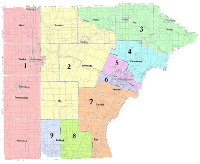
| + | === Monroe County Commission districts === |
||
| + | [[Image:MonroeDistricts.gif|thumb|right|200px|County Commission districts of Monroe County]] |
||
| + | *District 1: Western Monroe County; includes [[Dundee]], [[Petersburg]] |
||
| ⚫ | |||
| + | *District 2: Central Monroe County; includes [[Maybee]], [[Ida Center]] |
||
| + | *District 3: [[South Rockwood]]–[[Carleton]]; includes [[Berlin Charter Township]], [[Ash Township]] |
||
| + | *District 4: [[Frenchtown Charter Township|Frenchtown]] |
||
| + | *District 5: [[Monroe]]-North |
||
| + | *District 6: Monroe-South |
||
| + | *District 7: [[South Monroe]]–[[Luna Pier]]; includes [[La Salle Township]], portions of [[Erie Township|Erie]] and [[Monroe Charter Township]]. |
||
| + | *District 8: [[Temperance]] |
||
| + | *District 9: [[Lambertville]] |
||
== Cities, villages, and townships == |
== Cities, villages, and townships == |
||
| Line 60: | Line 77: | ||
*[[Detroit Beach]], [[Census-designated place|CDP]] |
*[[Detroit Beach]], [[Census-designated place|CDP]] |
||
*[[Lambertville]], [[Census-designated place|CDP]] |
*[[Lambertville]], [[Census-designated place|CDP]] |
||
| + | *[[Lulu]] |
||
*[[Newport]] |
*[[Newport]] |
||
*[[South Monroe]], [[Census-designated place|CDP]] |
*[[South Monroe]], [[Census-designated place|CDP]] |
||
| Line 106: | Line 124: | ||
** [[Lake Erie]] |
** [[Lake Erie]] |
||
** Michigan: Historic Crossroads |
** Michigan: Historic Crossroads |
||
| − | ** |
+ | ** Milan Village Hall & Fire Barn |
** Monroe |
** Monroe |
||
** Peter Seitz Tavern & Stagecoach Inn |
** Peter Seitz Tavern & Stagecoach Inn |
||
| Line 125: | Line 143: | ||
*[http://www.emerciv.com/ Emonroe.com Monroe County Calendar, Community Information & Ticketing] |
*[http://www.emerciv.com/ Emonroe.com Monroe County Calendar, Community Information & Ticketing] |
||
| + | {{Monroe County}} |
||
[[Category:Counties]] |
[[Category:Counties]] |
||
[[Category:Monroe County| ]] |
[[Category:Monroe County| ]] |
||
Latest revision as of 16:37, 29 July 2014
Monroe County is a county in southeastern Michigan. As of the 2000 census, the population was 145,945 with the 2007 Census Bureau estimate placing the population at 153,608. The county seat is Monroe. According to the United States Census Bureau, it forms a part of the Metro Detroit area; although, some communities in the southern portion of the county are more closely tied to Toledo, Ohio.
Economy[]
Monroe county features diversified industry, including auto-parts manufacturing, cement, glass making, metal fabrication, and packaging.[1] There is also a large agricultural component to the economy and culture of the county. Furthermore, the Fermi nuclear power plant is located east of Monroe and is owned by DTE Energy.
History[]
Monroe County was originally named for President James Monroe, in anticipation of his 1817 visit to the Michigan Territory.[2] The boundaries of Monroe county, however, have changed since its inception. Most notably, Toledo was formerly part of Monroe County, but was ceded to Ohio as a consequence of the 1835 Toledo War: a dispute between Ohio and Michigan fought over a 500 square mile of land, including the mouth of the Maumee River. In exchange for the loss of land in Monroe, Lenawee and Hillsdale counties, Michigan was granted the Upper Peninsula, then considered a wilderness.
The Battle of Frenchtown, one of the bloodiest battles in War of 1812 was fought in Monroe County. It was the largest conflict ever fought on Michigan soil. The River Raisin Battlefield is being considered for inclusion in the National Parks System.[3] The City of Monroe is one of the most historic cities in Michigan, and has a well marked trail of the battlefield.[4]
Geography[]
According to the United States Census Bureau, the county has a total area of 680 square miles (1,761 km²), of which, 551 square miles (1,427 km²) of it is land and 129 square miles (334 km²) of it (18.96%) is water.
Geographic features[]
Monroe is Michigan's only county whose entire shorline is comprised of Lake Erie, to the east. Fishing and boating are popular along coastal communities such as Estral Beach, Luna Pier, Monroe, and South Rockwood.
The River Raisin and Sandy Creek flow through the county. Wetlands, inlets and marshes abound along the lakeshore and near the mouth of the river. While the Sterling State Park is the only state park in the county, there are also numerous tracts of state-owned hunting land. The presence of waterfowl, shore birds and wildlife makes the area a favorite for birdwatchers duck hunters. The Detroit River International Wildlife Refuge also has land set aside in Monroe County.
Monroe county is rich in aleuvial soil, and its agricultural activities produce alfalfa, corn, grains, potatoes, soy beans, and sugar beets.
Adjacent counties[]
- Wayne County (northeast)
- Washtenaw County (northwest)
- Essex County, Ontario, Canada (east)
- Lenawee County (west)
- Lucas County, Ohio (south)
Government[]
 See also: Monroe County elections, 2008
The county government operates the jail, maintains rural roads, operates the major local courts, keeps files of deeds and mortgages, maintains vital records, administers public health regulations, and participates with the state in the provision of welfare and other social services. The county board of commissioners controls the budget but has only limited authority to make laws or ordinances. In Michigan, most local government functions — police and fire, building and zoning, tax assessment, street maintenance, etc. — are the responsibility of individual cities and townships.
Monroe County elected officials[]
- Prosecuting Attorney: William P. Nichols
- Sheriff: Tilman Crutchfield
- County Clerk/Register of Deeds: Sharon Lemasters
- County Treasurer: Kay Sisung
- Drain Commissioner: Daniel Stefanski
- Surveyor: Scott Warnke
- Nine Commissioners from nine districts.
(information as of January 2009)
Monroe County Commission districts[]
County Commission districts of Monroe County
- District 1: Western Monroe County; includes Dundee, Petersburg
- District 2: Central Monroe County; includes Maybee, Ida Center
- District 3: South Rockwood–Carleton; includes Berlin Charter Township, Ash Township
- District 4: Frenchtown
- District 5: Monroe-North
- District 6: Monroe-South
- District 7: South Monroe–Luna Pier; includes La Salle Township, portions of Erie and Monroe Charter Township.
- District 8: Temperance
- District 9: Lambertville
Cities, villages, and townships[]
Cities
- Luna Pier
- Milan (partial)
- Monroe
- Petersburg
Villages
Unincorporated
- Azalia
- Cone
- Detroit Beach, CDP
- Lambertville, CDP
- Lulu
- Newport
- South Monroe, CDP
- Stony Point, CDP
- Temperance, CDP
- West Monroe, CDP
- Woodland Beach, CDP
Charter Townships
Civil Townships
- Ash Township
- Bedford Township
- Dundee Township
- Erie Township
- Exeter Township
- Ida Township
- La Salle Township
- London Township
- Milan Township
- Raisinville Township
- Summerfield Township
- Whiteford Township
Education[]
- Airport High School
- Bedford High School
- Dundee High School
- Erie Mason High School
- Ida High School
- Jefferson High School
- Monroe High School
- Monroe County Community College
- Saint Mary Catholic Central
- Summerfield High School
- Whiteford High school
Local landmarks[]
- The Monroe County Social and Welfare Association is spearheading the development of the Phillip Murray – first president of the United Steelworkers of America and president of the Congress of Industrial Organizations – building into the Monroe County Labor History Museum.[5]
- The County contains ten registered state historical markers.[6]
Bibliography and further reading[]
- Clarke Historical Library, Central Michigan University, Bibliography on Monroe County
- Nicholas, J.R., G.L. Rowe, and J.R. Brannen. (1996). Hydrology, water quality, and effects of drought in Monroe County, Michigan [Water-Resources Investigations Report 94-4161]. Lansing, MI: U.S. Department of the Interior, U.S. Geological Survey.